Satellite are being used by journalists to report on conflicts, climate change, refugees, forest fires, illegal mining, oil spills, deforestation, slavery and many other topics. GIJN’s resource page provides official sources for free satellite images and links to experts who can advise on finding images, using them, handling technical issues and more.
Our weekly NodeXL curation of the most popular data journalism stories on Twitter features several climate change-related stories: snowless Winter Olympics, a look at the carbon footprint of popular food, how the world’s largest beef producer is fueling deforestation in the Amazon, and a Climate Promise Detector project reviewing the stance of presidential candidates on climate change in Costa Rica.
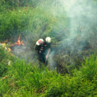
In March 2020, environmental journalist Helena Carpio, leaned out of her window to see Caracas filled with smoke. Something was burning, but no one knew where and there was no official news on what was happening. She started to investigate, and the resulting project analyzed two decades of satellite data on hotspots to explore the when, where, and why of forest fires in Venezuela and across Latin America.
Our NodeXL mapping from July 19 to 25, which tracks the most popular data journalism stories on Twitter each week, found imaginative data-driven coverage of the Olympics by The Washington Post, The New York Times, and other major outlets. In this edition, we also feature a piece by Reuters Graphics on how a Chinese lake has been decimated by sand mining, a cross-border investigation into the billion Euro business of elder care, and a deep dive into TikTok’s secretive algorithm by The Wall Street Journal.
For our “My Favorite Tools” series, we spoke with Brazilian journalist Gustavo Faleiros, editor of environmental investigations at the Pulitzer Center where he leads the Rainforest Investigations Network (RIN), about mapping deforestation and using data to chart what is happening in global forests.
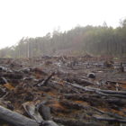
Every year the world loses 13 million hectares (32 million acres) of forests, an area about the size of Greece. A critical way to stem this forest loss is to make concessions data more transparent. This information is critical as it gives journalists, civil society groups and the public the information they need to hold the government and the private sector accountable for deforestation.
From the tropics to the Arctic, Indigenous peoples are on the front lines of the climate crisis. Investigative reporting is critical to tell their stories, delve into the causes and effects of global warming, and examine mitigation strategies.